Mapping tool for biodiversity risk assessments

Supporting cost effective decisions for environmental risk management

A Simple Index

For a chosen area, the LEFT tool assembles relevant environmental data from global databases. Within minutes, it produces a map displaying a simple index of ecological risk.

World-Class Algorithms

The LEFT tool uses algorithms formulated by researchers at the University of Oxford to assess the pattern of ecological features across a chosen area. These algorithms calculate the ecological risk index.

Local Assessments, Global Data

Any landscape in the world can be assessed - up to approximately 100,000km2 at a time. Output maps include information on: risk assessment; biodiversity; vulnerability; intactness; connectivity and resilience.

The LEFT Process

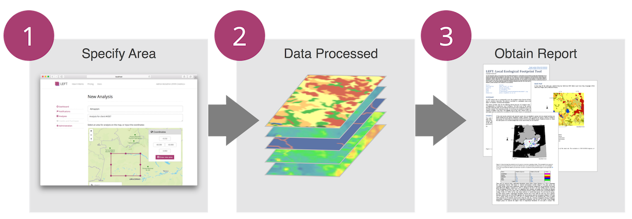
LEFT assembles data, performs an analysis and generates a report.

A decision support tool for land use and development planning

The algorithms for LEFT have been developed by our team at the University of Oxford, UK.


  • Algorithms developed from scientific literature
  • Globally consistent, up-to-date, high spatial resolution data
  • Provides geospatial data to download and use in a desktop Geographical Information System
  • Identifies potential operational and reputational risks
  • Helps inform land use planning
  • Supports corporate social responsibility reporting
Deciduous Forest

Used by Industry, Public Sector and Non-Governmental Organisations (NGOs)

  • Commercial: Infrastructure, Oil and Gas, Mining, Agribusiness, Tourism, Environmental Consultancy.
  • Public Sector: Local and National Government, International Agencies, Scientific Research.
  • NGOs: Environmental, International Development.
Forest and agricultural land